Poojitha D. Yapa
Professor of Civil and Environmental Engineering
Wallace H. Coulter School of Engineering
Clarkson University
An Integrated Oil and Chemical Spill Model For the St.Lawrence River Oil Spill Response
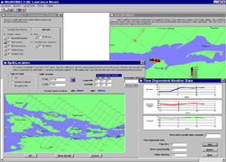
The current version of the Clarkson River Oil Spill Simulation Model - WinROSS is designed to run under windows. It is completely interactive and GUI Menu based. Data input, running the models (flow model an oil spill model), and output visualization all can be done from the GUI. The model is two-dimensional and has two-layers (surface and water column). It uses the Lagrangion Parcels Method. The model is an integrated part of the St. Lawrence River Oil Spill Preparedness Plan and is used by the St. Lawrence Seaway Development Corporation.
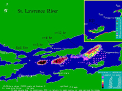
A 2-Dimensional 2-Layer Model was developed specifically for River Oil Spill Simulation (ROSS). Early versions of ROSS2 were applied St. Clair, St. Mary's and Detroit Rivers. Lake and River combined version LROSS was applied to Lake St. Clair/Detroit river system. A modified version ROSS2 of was applied to Ohio-Monangahela-Allegheny river system. This river system is complex in many ways: the total river system length is over 300 miles; the rivers have many meanders; the system has many navigation Locks that make the simulation difficult. Figure on left shows a sample simulation for St. Lawrence River. The model considers Environmental Sensitivity Index (ESI) of the shorelines in computing oil deposition on the shore. The ESI for the shoreline can be displayed in color.
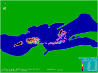
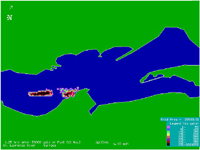
A modified version of ROSS2 was applied to St. Lawrence River. This model is part of the St. Lawrence River Oil Spill Preparation Plan. ROSS3 was developed specifically to improve simulations in rivers and handle branching rivers. ROSS 3 was applied to St. Clair river/tidal flat system. The model also simulates oil spill under conditions changing shoreline locations. ROSS 2 and ROSS3 were also available in Integrated versions where the users could enter data through interactive menus and visualize the results through the same interface.
With the advent of the Windows era ROSS2 was modified for and a GUI was added. This version is named WinROSS and has been applied to St. Lawrence River.

Experimenting, Developping Models and Sharing Knowledge on Deep Water Oil Related Problems for more than 20 Years

Clarkson University has a worldwide reputation for its leading oil and gas computational research More >>
Contact
- E-mail:
- pdy at clarkson dot edu
- Telephone:
- 315-268-7980
- Fax:
- 315-268-7985
- Address:
- Clarkson University
Box 5710,
130 Rowley Laboratories, Potsdam,
NY 13699-5710 U.S.A.